Background
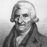
Cassini was born on June 17, 1714, in Thury-sous-Clermont, France, the son of Jacques Cassini and Suzanne-Françoise Charpentier de Charmois.

Astronomer cartographer scientist
Cassini was born on June 17, 1714, in Thury-sous-Clermont, France, the son of Jacques Cassini and Suzanne-Françoise Charpentier de Charmois.
Cassini studied at the family home in the Paris observatory under the guidance of his granduncle G. F. Maraldi, who developed his very precocious gift for astronomy.
Cassini's career began when the debate in France between the Cartesians and the Newtonians reached its peak. In particular the quarrel over the form of the terrestrial spheroid - essentially the question of whether it was elongated or flattened along the line of the poles - had taken on a symbolic value at the Académie des Sciences, the Cartesians defending the first point of view and the Newtonians the second. From 1683 to 1718 Cassini I and Cassini II had directed major geodesic operations designed to determine the meridian of Paris, an 8°30' arc of the great circle stretching between the northern and southern frontiers of France. The brilliant confirmation of the Cartesian view that Cassini II (in 1718 and 1722) thought he had derived from the results of these measurements appeared to be a victory for the Cartesians. After some hesitation the Newtonians counterattacked, contesting the accuracy and the conclusiveness of these results. Feeling the necessity of presenting new arguments in favor of the theory of elongation, Cassini II decided to undertake the determination of the arc of the great circle perpendicular to the meridian of Paris, an operation also of great interest for the establishment of the map of France. With the aid of several collaborators, including his son César-François, Cassini II determined the western portion of this perpendicular (between Paris and Saint-Malo) in 1733, and in 1734 the eastern portion (between Paris and Strasbourg). These operations familiarized César-François with the theory and practice of geodesic operations and as early as 1733 he presented an argument for the importance of such operations before the Academy of Sciences. The Academy named him supernumerary assistant on 12 July 1735. He became a regular assistant on 22 January 1741, an associate in the section of mechanics on 22 February 1741, and a full or “pensioned” member of the section of astronomy on 25 December 1745.
Although these new measurements seemed to confirm the hypothesis of the elongation of the terrestrial spheroid, the Académie des Sciences decided to organize major geodesic expeditions to Peru (1735-1744) and to Lapland (1736-1737) in order to settle the debate by measuring arcs of meridians at very different latitudes. In 1735-1736 Cassini III directed new geodesic operations designed both to bring new elements into this dispute and to complete the guidelines of a rough draft of a new map of France; assisted by his father’s principal collaborators, he determined the two demiperpendiculars to the meridian of Paris, which were run to the west at a distance of 60,000 toises north and south of the Paris Observatory. But the return of the Lapland expedition at the end of August 1737 and the presentation, a few weeks later, of its first results, which supported the Newtonian theory of flattening, did not settle the argument. As a result, attempts to verify the meridian of Paris were undertaken in 1739 and 1740.
Meanwhile, Cassini had become opposed to the theory previously held by his family and took responsibility for conclusions resulting from this position (La méridienne de l'Observatoire royal de Paris véripée dans toute l'étendue du royaume, 1744). Having succeeded in this difficult conversion, he gave up all argument on the subject and devoted himself to astronomical observation and to the establishment of a new map of France, at the same lime leading a rather brilliant social life. In 1748 Cassini was named maître ordinaire at the chambre des comptes and also obtained the office of conseiller du roi. A foreign member of the Royal Society and of the Berlin Academy, he later renewed his ties with Italy and with his family’s native city, Bologna.
Cassini’s astronomical work is not very remarkable: observations of lunar and solar eclipses and of occultations of stars and planets, determinations of solstices, the study of the trajectories of comets, and improvements in the details of the construction and use of instruments. The financial aid that he requested to restore the observatory building, to purchase observational instruments, and to improve the functioning of that establishment were not granted until 1785, as part of a complete reorganization of its regime. His son, Cassini IV, had just succeeded his father as director of the observatory, a post created by the king in 1771. He had assisted his father during his last years, which Cassini III spent in semiretirement.
Cassini’s essential work, however, was in cartography. The various geodesic operations undertaken in France from 1733 to 1740 by the teams from the observatory, as well as other triangulation projects conducted along the coasts and land borders, had already provided the essential elements for a new map of France. The 400 principal triangles constructed on eighteen bases, mentioned by Cassini III in 1740, were completed during the following years, permitting him to produce the new map in eighteen sheets on the scale 1:870,000. Announced to the Academy in November 1745, it was not published until 1746 or 1747. This map, however, was actually only a preliminary work. In 1746-1747 Cassini carried out important cartographical operations in Flanders and in the Netherlands which were highly valued by the king, who delegated to him the responsibility of establishing a new map of Franee on this model. Adopting the scale of 1:86,400 and relying on triangulations already made, Cassini drew up the plan of a map in 182 sheets; he predicted that its cost of execution would be more than 700,000 livres and that it would require the work of several groups of specialists for about twenty years. The project having been officially adopted, Cassini ordered the necessary material and undertook the training of various specialists. The surveying began in 1750, but the discontinuance of financial aid from the state interrupted the work in 1756. Then, under the patronage of the Académie des Sciences, he organized a private financial society which permitted the resumption of activity. In spite of numerous difficulties the work progressed, thanks especially to the help of devoted collaborators: geometers, engineers, and engravers, such as Pierre-Charles Capitaine (d. 1778) and his son Louis (1749-1797).
At the time of the death of Cassini in 1784, only the map of Brittany remained to be done. Cassini IV continued this great work, which was almost finished when the Revolution began. The magnitude and the quality of this work, the first modern map of France, overshadow Cassini’s other accomplishments, such as the projects for the extension of the French network of triangulations toward Vienna (1761, 1775) and toward England (accomplished after his death) and his participation in measurements of the speed of sound (1738). While he was a good geodesist and a talented cartographer, Cassini III was only a second-rate astronomer; and the name of this third representative of the Cassini dynasty at the Paris Observatory will remain associated with the first map of France produced according to modern principles.
In 1747 Cassini married Charlotte Drouin, daughter of Louis-François, seigneur of Vaudeuil; they had a son, Jean-Dominique, who succeeded his father as astronomer and geodesist under the name Cassini IV, and a daughter, Françoise-Elisabeth.


