
Background
Gerardus Mercator was born on March 5, 1512, in a St. Johann hospice in Rupelmonde, Glanders, in the Burgundian Netherlands, now in Belgium.

(Gerardus Mercator can confidently be called the greatest ...)
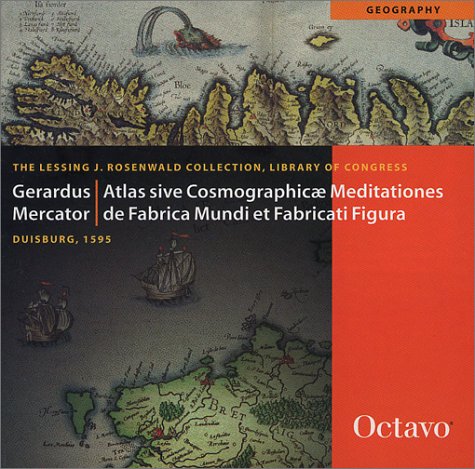
Gerardus Mercator can confidently be called the greatest cartographer of the sixteenth century. His most famous contribution to science is a technique of rendering the globe on a flat surface, still known as "Mercators projection," that was first used for a 1569 world map. No less significant was the publication in 1595, one year after the authors death, of the complete Atlas sive Cosmographicae meditationes de fabrica mundi et fabricati figura (Atlas, or Cosmographic Meditations on the Fabric of the World and the Figure of the Fabrickd). With this volume, a collection of maps was linked for the first time with the figure of Atlas, the Greek Titan, condemned by Zeus to carry the vault of heaven on his shoulders. For Mercator, geographical description was more than the practical matter of locating places or showing how to get from one point to another. The cartographer was able to split the world in unfamiliar and uncomfortable ways, but he also had the means, through mathematical reasoning, to bind it up so that it approached a divine unity. Although the idea of bringing maps together into a book did not originate with Mercator, he can certainly be called the first modern, scientific cartographer. His early charts, used with a magnetic compass (and an awareness of compass declination) gave the sailor the most reliable guide he had ever possessed. No one else could claim the breadth of his understanding of terrestrial magnetism and map projection. Mercator also published the first manual of the italic hand to be printed outside Italy; he used italic exclusively on his maps and it, too, has remained a staple of cartography up to the present day. This particular copy of Mercators Atlas is exceptional for its beautiful hand-coloring. Commentary by Robert W. Karrow, Jr., essay on color in cartography, English translation.
http://www.amazon.com/gp/product/1891788264/?tag=2022091-20
(Mark Twain once famously said "there was but one solitary...)
Mark Twain once famously said "there was but one solitary thing about the past worth remembering, and that was the fact that it is past and can't be restored." Well, over recent years, The British Library, working with Microsoft has embarked on an ambitious programme to digitise its collection of 19th century books. There are now 65,000 titles available (that's an incredible 25 million pages) of material ranging from works by famous names such as Dickens, Trollope and Hardy as well as many forgotten literary gems , all of which can now be printed on demand and purchased right here on Amazon. Further information on The British Library and its digitisation programme can be found on The British Library website.
http://www.amazon.com/gp/product/B003OBZVJC/?tag=2022091-20
cartographer geographer cosmographer
Gerardus Mercator was born on March 5, 1512, in a St. Johann hospice in Rupelmonde, Glanders, in the Burgundian Netherlands, now in Belgium.
He matriculated from the ‘University of Louvain’ on August 29, 1530 with philosophy and humanities.
He studied for a two-year degree course at this university on Arts subjects that were based entirely on the teachings of Aristotle.
In 1852 he graduated with a master’s degree but did not study further as he felt an urge to challenge the views of Aristotle and the Catholic Church about Earth’s creation.
He left the university because he did not want to become a philosopher unable to reconcile the teachings of Aristotle to the teachings of the Bible about the origin of the Earth.
Gerardus Mercator started teaching mathematics to students at Louvain while he was still learning the subject. He also started making high quality mathematical instruments and sold them to others with the permission of the university to earn some money.
He constructed the first terrestrial globe in 1535 with the help of Gemma Frisius and Van der Heyden. For the first time copper blocks were used instead of wooden blocks to print the paper for the globe. Gemma Frisius looked after the geographical details while Van de Heyden did the engraving.
In 1537 Gerardus made a globe of the stars again with the help of Gemma Frisius and Van der Heyden. This time Gerardus played a bigger role in its creation.
Gerard Mercator created his first world map in 1538.
He made a map of Flanders in 1540 for political purposes with the help of a survey and the triangulation process suggested by Gemma Frisius.
He produced a map of Europe in the summer of 1540 which had a lot of inconsistencies due to the wrong information given by sailors.
He corrected the problems with the ‘loxodrome’ also known as the ‘rhumb line’ or ‘sperical helix line’ and created a new globe in 1541.
In February 1544 he was suspected as a Lutheran because of his Protestant beliefs and imprisoned for seven months in the Rupelmonde castle. He was released in September 1544 with the help of the ‘Louvain University’.
He completed the celestial globe in 1551 in line with his earlier terrestrial globe. He corrected the positions of the stars with the help of Copernicus’ model of the universe.
He moved to Duisburg in 1552 and opened a cartographic workshop in anticipation of the requirement for maps.
He brought out a 1. 6 meters long and 1. 3 meters wide map of Europe in 1554.
Mercator taught mathematics from 1559 to 1562 to students wanting to enter the proposed university at Duisburg but gave it up when the plan for the university was scrapped in 1562.
He created the maps of Lorraine and the British Isles in 1564 of which the latter was used for political purposes against Protestant Queen Elizabeth.
He was appointed as the ‘Court Cosmographer’ to Duke Wilhelm of Cleve in 1564.
In 1569 he created the famous ‘Mercator projection’ which was a world map on 18 separate sheets and named it ‘atlas’. The maps had parallel lines running from top to bottom and from side to side representing the longitudes and the latitudes. This caused the map to be fairly accurate at the center but produced distorted shapes of land masses at the sides.
In 1578 he published the corrected and updated maps created by Ptolemy.
In 1585 he tried to include Germany, France and the Netherlands in his map but could not complete his project. His maps in 1589 included the Balkans or Sclavonia and Greece.
After having a stroke in 1590 he was unable to complete any of his projects. By 1592 he had lost his sight and after the second stroke in 1593 he was totally paralyzed. His incomplete works were published by his son in 1595.
(Mark Twain once famously said "there was but one solitary...)
(Gerardus Mercator can confidently be called the greatest ...)
His marriage to Barbara Schellekens was in September 1536 and Arnold, the first of their six children, was born a year later.
