Tadataka Ino was a Japanese astronomer, geographer and surveyor. He is credited for creating the first map of Japan using modern surveying techniques.
Background
Tadataka Ino was born on February 11, 1745, in the small village of Ozeki in the middle of Kujukuri beach, in Kazusa Province (now Chiba Prefecture). He was born to the Jimbo family and his childhood name was Sanjirou. The son of Sadatsune Jimbo, Ino had an unhappy childhood. His mother died in 1751, and because his father and his stepmother could not support him he stayed with various relatives.
He was later adopted by a wealthy landowner and brewer named Ino and took his surname.
Education
Ino applied himself to the study of mathematics, astronomy, and surveying. At the age of fifty, he became a student of Takahashi Yoshitoki, an official astronomer in the service of the shogunate, studying various methods of astronomical observation and matters pertaining to the calendar.
Career
Ino was an able businessman, managing a brewery, buying and selling grain, and setting up a firewood warehouse in Tokyo. In 1794 Ino officially retired.
His formal scientific studies began only at the age of fifty, and from then until the age of seventy-three, two years before his death, he worked energetically in astronomical surveying. At the time that Ino became Takahashi’s pupil, the Asada school was the most prominent in Japanese astronomy. Although Asada Goryu himself was past his prime, his students Takahashi and Hazama Shigetomi were revising the calendar based upon such Sino-Jesuit works as Li-hsiang K’ao-ch'eng. In 1897 the Kansei revision of the calendar was completed.
A major astronomical and geodetic problem of the time in Japan was the finding of the length of a meridian by Japanese measure. Since Li-hsiang K'ao-ch'eng had set zero longitude at Peking, that of Japan had to be accurately measured so that, in predicting a solar eclipse, the Sino-Jesuit method could be employed for the Japanese longitude.
In order to find the length of a meridian Ino volunteered to undertake a geodetic survey. Takahashi negotiated for him with the government, and in 1800 official permission for the survey was received. The Asada school was interested in the project from the point of view of astronomical geodesy, but the government permitted the private survey in hopes that it would contribute to the defense of northern Japan against possible Russian encroachments. The Russians had been active in the north since the end of the eighteenth century and the Japanese now wanted a coastal survey of Hokkaido, there being no satisfactory marine chart of that coast.
With several followers, Ino set out for Hokkaido via the northern part of the main island of Honshu. During the day they measured distances by number of steps and the bearings of distant mountains. At night, using a quadrant, they observed the altitude of a fixed star as it crossed the meridian. After compiling the results of their survey, Ino produced a map and presented it to the government. He subsequently conducted many successful surveys in northeastern Japan. His success aroused enthusiasm for surveying among many of his followers, especially Honds Rimei.
In 1804 Ino undertook a government project to survey the western seacoast of Japan. In comparison with the privately done, somewhat inexact survey of northeastern Japan, which had been carried out with insufficient personnel and funds, this better supported, government-sponsored survey of western Japan was very accurate and detailed; there was a larger budget, and personnel were also allowed various privileges on the site. After making over 2,000 measurements of latitude, Ino calculated the length of a meridian which agreed with the figure given in the Dutch translation of Lalande’s Astronomie (1775), which source Takahashi had obtained in 1803.
On Inos' maps zero longitude is through Kyoto. Ino tried to utilize celestial observation to measure longitude, as by noting, for instance, the solar and lunar eclipses from two different points and by observing an eclipse of a satellite of Jupiter. He had to revert, however, to fixing longitude by measuring distances along the earth’s surface. This procedure affected the accuracy of his maps, especially that of Hokkaido, in which there was a systematic error of several tenths of a minute.
In addition to his maps, Ino produced scholarly works on surveying and mathematics, including Chikyu sokuenjutsu mondo and Kyukatsuen hassenho.
Achievements
Despite his scientific failings, Tadataka Ino's map of Japan, based upon surveys covering the length and breadth of the land, has an important place in geographical history. His map of Japan was far superior to maps then in use, and to an amateur, his results look almost like modern maps. It was a revolutionary step forward. George Sarton compares his contribution with that of Ferdinand Hassler, founder of the U.S. Coast and Geodetic Survey.
Ino is celebrated as one of the "architects" of modern Japan. A museum, dedicated to his memory, was opened in his former home in Sawara, and in 1996 was designated a National Historic Site.
In November 1995 the Japanese government issued a commemorative 80 yen postage stamp, showing Ino's portrait and a section of his map of Edo.
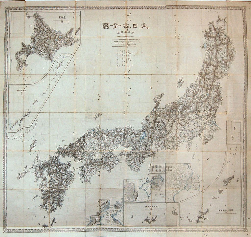
(Folding map of Japan based on survey work performed by Ta...)
1878
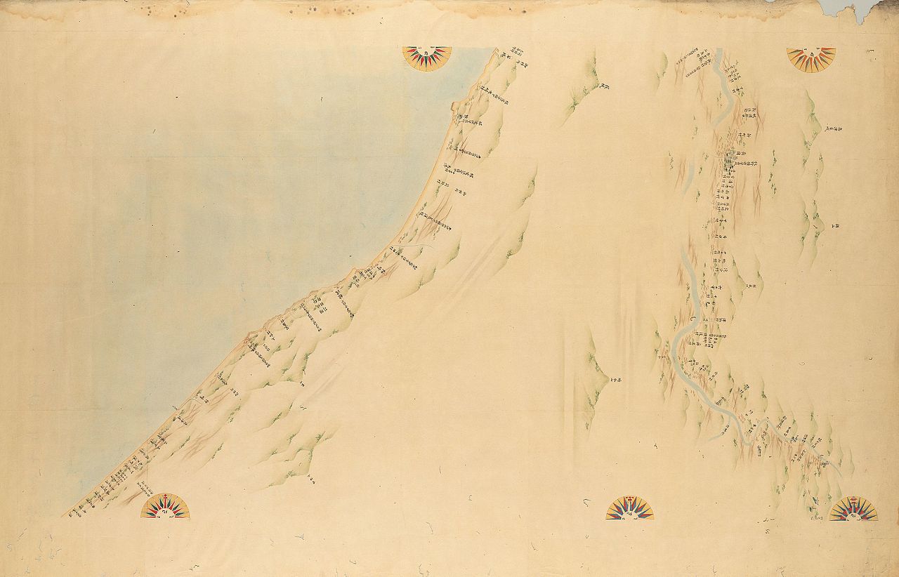
Map of Echigo Province
(Dai Nihon Enkai Yochi Zenzu No. 76, Echigo Province (Echi...)
Views
When calculating the length of the meridian, Ino considered the earth as a perfect sphere rather than a spheroid. Moreover, when observing the positions of fixed stars, he did not take into account the effects of refraction, parallax, or nutation. In his surveying, Ino did not use modern triangulation but relied upon the old traverse method. His mapmaking approach resembled the Sanson-Flamsteed method, which is appropriate only for small areas; Ino nonetheless used the method for an area as large as all of Japan.
Personality
Ino was an energetic field observer but did not excel in devising new methods or new theories in either astronomy or geodesy. While he was active, knowledge of Western astronomy was available through Dutch translations and Sino-Jesuit works and, later, through the works of Lalande; but Ino had no knowledge of Dutch or dynamics and little understanding of astronomical theories.
Connections
In 1762 Ino married a girl four years his senior, the daughter of a wealthy landowner and brewer named Ino. His wife died in 1784, and he remarried in 1790.