Background
Bruce Charles Heezen was born on April 11, 1924 in Vinton, Iowa, United States. His father, Charles Christian Heezen, managed farm properties for an insurance company, then acquired his own farm near Muscatine, Iowa, on which he raised turkeys. His mother, Esther Christine Shirding, had taught dramatics in high school before their marriage and had considerable artistic talent. Heezen was their only child. He helped his father on the turkey farm (thereby acquiring a lifelong distaste for the product) and showed an early interest in science.
Education
In 1942 Heezen enrolled at the University of Iowa; his studies were interrupted for two years during World War II, when he worked on his father's farm. In his third year of studies Heezen took a course in geology, and in the summer he collected conodont fossils in Nevada with a graduate assistant lecturer, Walter Youngquist.
Fairly well on his way to a career in paleontology, in 1947 he attended a Sigma Xi lecture given by Professor Maurice Ewing of Columbia University.
Ewing invited Heezen to join him on an expedition at sea the following summer. At the last minute Heezen was put in charge of the work on the smaller of the two vessels, Balanus. He obtained two hundred photographs of the seafloor and many cores, which set him onto a career of studying the ocean floor.
After receiving the Bachelor of Arts from the University of Iowa in 1948 and spending more months at sea, he became a graduate student at Columbia University, where Ewing had just established Lamont Geological Observatory for his growing research group. Heezen received the Master of Arts in 1952 and the Ph. D. in 1957 from Columbia University.
Career
Heezen was appointed research associate there in 1956, senior research scientist at Lamont Geological Observatory from 1956 to 1958, then assistant professor in the geology department at Columbia in 1960, where he advanced to associate professor in 1964.
Heezen's research began with a small number of sounding records in the North Atlantic. Early expeditions with an improved sounding device, the precision depth recorder, showed that vast areas of the seafloor were flat, and coring proved that the sediments were often coarse-grained sands. From the sequence of breaks in transatlantic cables caused by an earthquake in 1929, Heezen presented in 1952 the idea that turbidity currents can rapidly transport vast amounts of sediment far out to sea. These flows of sand and water created by submarine landslides had been first proposed by Reginald Daly and were demonstrated later by Philip Kuenen in tank experiments. After Ewing and Heezen determined that the Hudson Submarine Canyon was at least 15, 000 feet deep, they proposed that turbidity currents can scour submarine canyons from the continental shelf. Later, with colleagues and students, Heezen found that deep currents caused by the Coriolis effect along the continental margins also transport and redeposit sediments in vast drifts on the seafloor.
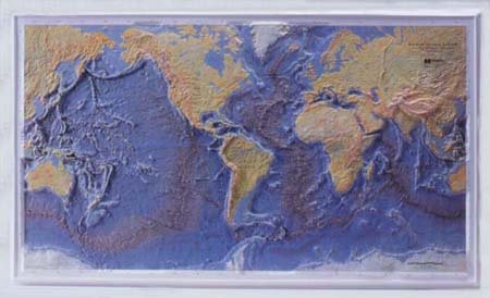
The Mid-Atlantic Ridge was a feature that had been recognized but not surveyed. Using six profiles across the ridge obtained by Ewing and former colleagues at Woods Hole Oceanographic Institution, Heezen worked with research assistant Marie Tharp to create a map (1952). Tharp noted that on each profile, the crest of the ridge showed a deep valley. As more data came in from expeditions at sea, the great extent and continuity of the Mid-Atlantic Ridge became clear. Partly because of restrictions by the United States Navy on publication of contour charts, Heezen and Tharp instead produced in 1959 a three-dimensional physiographic diagram of the North Atlantic Ocean, after the style of Columbia geologist Armin K. Lobeck for terrestrial presentation. While plotting thousands of earthquakes to explain submarine cable breaks for Bell Laboratories, Heezen observed in 1952 that the earthquakes coincided with the rift valley that Tharp had noted, and concluded that the valley itself was a tension fault caused by earthquakes.
In 1956, Ewing and Heezen proposed a world-girdling mid-ocean ridge system with an axial rift that was seismically active. Incorporated into the global system were the terrestrial rift valleys of eastern Africa, the San Andreas fault system in California, and the tension cracks near Iceland. Over the next two decades, Heezen and Tharp in close collaboration produced physiographic diagrams of the South Atlantic, the Indian Ocean, the west-central Pacific, and finally the floors of all oceans. These panoramic views and globes, widely distributed chiefly by the National Geographic Society, clearly illustrate the 40, 000-mile extent of the almost continuous seafloor mountain range and rift zone.
A summary of the collaborative work, painted by Henrich Berann, was completed just before Heezen's departure on his final sea voyage in 1977. Heezen at first proposed an expanding Earth to account for the new material being produced at the rift centers. It gradually became clear to oceanographers that the rifts represented plate boundaries, since the theory of global plate tectonics advocated that new material is thrust onto the seafloor at the rifts and older material descends at the deep trenches.
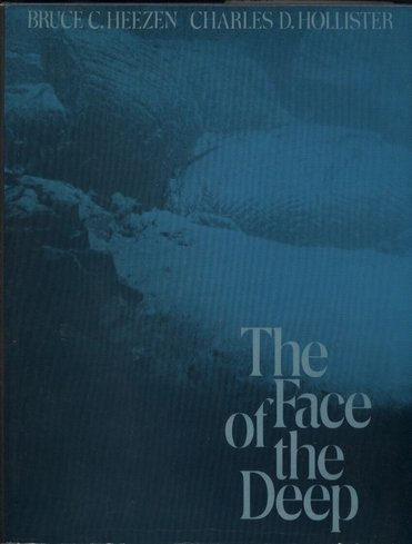
Heezen spent a great deal of time at sea, where he seemed to be indefatigable, ever fascinated by new information. He worked closely with his graduate students, who often accompanied him aboard ship. His interests extended to all aspects of seafloor sedimentation. He identified spiral patterns that appeared in deepsea photographs as the tracks left by a bottomdwelling acorn worm. He theorized that tektites dredged from the seafloor were evidence that a celestial object had exploded 700, 000 years earlier. While analyzing cores from the Mediterranean with Dragoslav Ninkovich, he suggested that beds of ash there represented material from an explosive eruption of Santorini volcano in the Aegean Sea, which destroyed the Minoan civilization on Crete and was perhaps the origin of the legends of Atlantis. Deep-sea photographs were a favorite tool of Heezen's, and hundreds of them appeared in the book he wrote with Charles D. Hollister, Face of the Deep (1971).
In the late 1960s, Heezen began participating in United States Navy programs using submersibles and research submarines, so that he could see the undersea features directly and determine photo sites himself. He was aboard the navy research submarine NR-1, preparing for a dive near Iceland, when he died of a heart attack.